DonateMembershipVisit Heritage
  • Tūrangawaewae
    Places
  • Tira Māori
    Māori Heritage
  • Poutairangahia
    Archaeology
  • Rauemi
    Resources
  • Mō Tātou
    About Us
  • New Zealand Heritage List
  • Nominate and submit
  • Explore the List
  • National Historic Landmarks
  • Plaques
  • Rainbow List Project
  • Lost heritage
  • Visit Heritage
  • Our properties
  • Turnbull House Project
  • Collections
  • Shop
  • Tohu Whenua
  • Tira Māori
  • Conserving Māori heritage
  • Marae built heritage
  • Māori heritage on the List
  • Hinemihi—Te Hokinga Mai
  • What is archaeology?
  • Is there a site on my property?
  • What are my legal requirements?
  • Affecting an archaeological site
  • Declaring an archaeological site
  • Archaeology FAQs
  • Archaeology Digital Library
  • Archaeology guidelines and templates
  • Resources
  • Funding
  • Publications
  • Sustainable management guides
  • Disaster recovery
  • Podcasts & digital resources
  • Education Hub
  • Conservation plans
  • About
  • Board
  • Māori Heritage Council
  • Senior Staff
  • Offices
  • Contact us
  • Careers
  • Covenants
  • Fast-track
  • Corporate documents
  • Currently consulting on
  • Our submissions
  • News
  • Covid-19 response
Quick links
Rārangi Kōrero | The List
Explore the List
National Historic Landmarks
Ngā Manawhenua o Aotearoa me ōna Kōrero Tūturu
Quick links
Tapuwae
A Vision for Places of Māori Heritage
Funding for Māori Heritage
Resources
Quick links
Archaeological Authority Portal
Applying for an archaeological authority
Archaeology FAQs
Browse the most frequently asked questions about archaeological authorities and the archaeological process.
Quick links
Quick links
News
News Keep up to date with Heritage New Zealand Pouhere Taonga
Membership
Membership Find out more and sign up today
  • Places
  • Nominate and submit
  • National Historic Landmarks
  • Places
  • Nominate and submit
  • National Historic Landmarks
  • Tira Māori
  • Conserving Māori heritage
  • Marae built heritage
  • Tira Māori
  • Conserving Māori heritage
  • Marae built heritage
  • Archaeological authorities
  • Archaeology Digital Library
  • Archaeological authorities
  • Archaeology Digital Library
  • All resources
  • Publications
  • Funding
  • All resources
  • Publications
  • Funding
  • FAQs
  • FAQs
Follow us on:
Places
  • Places
  • Nominate and submit
  • National Historic Landmarks
Tira Māori
  • Tira Māori
  • Conserving Māori heritage
  • Marae built heritage
Archaeology
  • Archaeological authorities
  • Archaeology Digital Library
Resources
  • All resources
  • Publications
  • Funding
FAQs
  • FAQs
Follow us on
HomePrivacyTerms and conditionsAbout this site
© Heritage New Zealand Pouhere Taonga 2026.
 
Kawarau Gorge Suspension Bridge

1693 Gibbston Highway (State Highway 6), Gibbston, QUEENSTOWN

Public

Historic Place Category 1

List No. 50

Quick links:
List GalleryLocationDetails
Opened in 1880 and said at the time to have the longest single span in the colony, the Kawarau Suspension Bridge is the premier surviving example in Otago of the lengths taken to provide the interior of the region with reliable connections to the wider world; in terms of engineering challenges it was considered a project conceived by a “genius of a daring order”. Within a very short time following its completion it was recognised as an appealing attraction to travellers to the area. As such it has commendable technical, historical and aesthetic values.

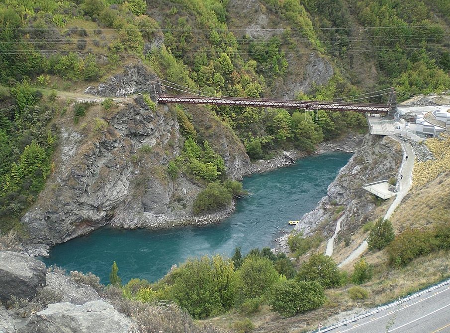
Ngāi Tahu whānui had developed a complex series of trails throughout Te Waipounamu over generations of occupation, connecting kāinga with one another and to mahinga kai and other significant tribal resources. The Kawarau River was a traditional ara that provided access from coastal areas (via the Mata-au / Clutha River) to Whakatipu Waimāori / Lake Wakatipu and beyond. It was also considered a kāinga mahinga kai (food-gathering place) where weka, kākāpō, kea, and tuna (eel) were gathered. Early European settlers, often guided by Māori, used similar routes to penetrate the interior of Te Waipounamu and once settlement grew, roads and river crossings were essential to maintain communication with the outside world. Most early river crossings were punts; the crossing of the Kawarau being at the Morven Ferry Punt, situated at a point 3.7km upstream from the current crossing; this served as a means to cross the river from the 1860s into the 1870s. However, easily constructed crossings, such as punts and bridges constructed on low-lying river flats, came with issues, most notably floods, which frequently destroyed this type of infrastructure, cutting communities off from the outside world. Early proposals for a Kawarau bridge construction focused on easily constructed bridges in these low-lying areas, but none eventuated. By the late-1870s the Government was persuaded to provide £8,000 for the construction of a bridge. In 1879 the final decision was made regarding the bridge’s position and tenders were called for its construction; H. P. Higginson of Dunedin was the engineer, with the tender eventually awarded to John McCormick in September.

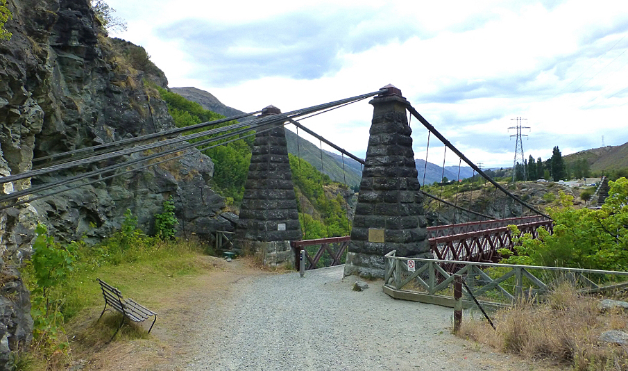
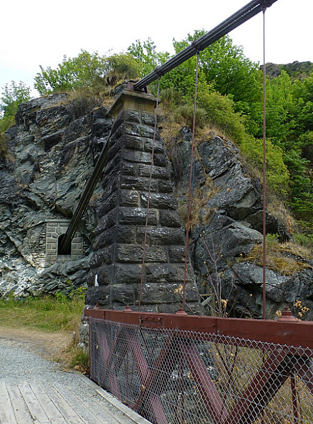
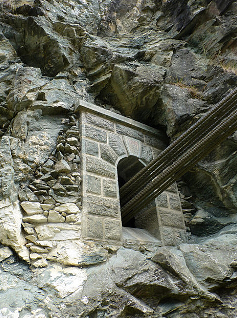
The bridge was built within 15 months and opened in December 1880. At its opening it was described as having ‘one span 300ft. [91.4m] long (the longest span, we believe, in the colonies) and an altitude of 150ft. [45.7m] above the river level’; the cost of the entire contract, which included two additional bridges and several miles of road, was reported at £13,000. The project required a high standard of engineering, the sharp turn of the road at the northern bank necessitating the construction of deep tunnels into the rock cliff face to anchor the cables; the towers on both sides were constructed of ashlar, sourced with ‘considerable difficulty’, and the nearly 5 inch (123.8mm) cables had to be sourced from England. The opening of the bridge was attended by some 500 people, including leading members of the Queenstown and Arrowtown communities; the Queenstown Brass Band provided entertainment. Shortly following its construction, in 1882, the engineering prowess necessary for this project was recognised by the awarding of a “Telford Premium” to H. P. Higginson, the engineer.

The bridge operated from late-1880 through to 1963, when a new bridge was constructed about 230m upstream; later efforts were made to preserve the original bridge, with ‘more than $100,000’ being spent of structural upgrades in the late-1980s. In 1988, the first iteration of A. J. Hackett’s Bungy Jumping operation was opened on the bridge and since then the bridge has moved to the top of many a tourist’s must-see list.

Kawarau Gorge Suspension Bridge. CC BY 2.5 Image courtesy of commons.wikimedia.org | Mat Cross | 30/03/2007 | Mat Cross - Wikimedia Commons
Kawarau Gorge Suspension Bridge. Image courtesy of www.flickr.com | Shelley Morris – Shells | 22/01/2016 | Shelley Morris
Kawarau Gorge Suspension Bridge. CC BY 2.5 Image courtesy of commons.wikimedia.org | Mat Cross | 30/03/2007 | Mat Cross - Wikimedia Commons
Kawarau Gorge Suspension Bridge. Image courtesy of www.flickr.com | Shelley Morris – Shells | 22/01/2016 | Shelley Morris

List Entry Information

Overview

Status
Listed

List Entry Status
Historic Place Category 1

Access
Able to Visit

List Number
50

Date Entered
26th November 1981

Date of Effect
26th November 1981

City/District Council
Queenstown-Lakes District

Region
Otago Region

Extent of List Entry

Extent includes part of the land described as Secs 63-64, Blk I Kawarau Survey District (RT OT15C/465, 87392), and part of the land described as Legal River (NZ Gazette 1983 p.2010-11), Otago Land District and the structural elements which form the Kawarau Gorge Suspension Bridge. The Extent excludes any structures associated with the bungy jumping operation. Refer to the extent map tabled at the Heritage List/ Rārangi Kōrero Committee meeting on 29 April 2021.

Legal description

Secs 63-64, Blk I Kawarau Survey District (RT OT15C/465, 87392) and Legal River (NZ Gazette 1983 p.2010-11), Otago Land District

Detailed List Entry

Construction Professional

Name

McCormick, J

Type

Builder

Biography

Contractor for the 1887 Roxburgh Suspension Bridge

Name

Harry Pasley Higginson

Type

Engineer

Biography

No biography is currently available for this construction professional

Construction Details

Start Year

1963

Type

Other

Description

[Road over the bridge closed in favour of a modern alternative]

Start Year

1880

Type

Original Construction

Reference

Public NZAA Number

F41/426

Completion Date

17th March 2021

Report Written By

Andrew Winter

Information Sources

Astwood, 2011

Astwood, Karen (2011) ‘Kawarau Gorge Suspension Bridge - IPENZ Engineering Heritage Register Report’, Engineering New Zealand

Thornton, 1987

Thornton, J. (December 1987) ‘Anchored Above a Gorge’, Historic Places, New Zealand Historic Places Trust, pp 12-14

Timmins, 1996

Timmins, R. (1996) ‘The Kawarau Bridge’, The Queenstown Courier, Queenstown & District Historical Society, pp 7-11

Winter, 2014

Winter, Andrew (2014) The Queenstown Trail – Archaeological Assessment of Effects Report, Jackie Gillies and Associates

Report Written By

This place was identified as significant under previous legislation with different information requirements. It remains significant under the current legislation. There is opportunity under our legislation and policies to add to this information. Further information about this place may be available from the Otago/Southland Office of Heritage New Zealand Pouhere Taonga. A fully referenced upgrade report is available on request from the Otago/Southland Area Office of Heritage New Zealand. Title held in fee simple. Land originally gazetted: NZG 1979 p.1605 Please note that entry on the New Zealand Heritage List/Rarangi Korero identifies only the heritage values of the property concerned, and should not be construed as advice on the state of the property, or as a comment of its soundness or safety, including in regard to earthquake risk, safety in the event of fire, or insanitary conditions.

Further Information

Current Usages

Uses: Civic Facilities

Specific Usage: Bungy Jumping Operation

Uses: Civic Facilities

Specific Usage: Cycle Trail

Uses: Civic Facilities

Specific Usage: Historic or recreation reserve

Former Usages

General Usage:: Transport

Specific Usage: Bridge/ Viaduct

General Usage:: Transport

Specific Usage: Road

Themes

Web Links

description: Engineering NZ Heritage

url: https://www.engineeringnz.org/our-work/heritage/heritage-register/kawarau-gorge-suspension-bridge/

Overview

Status

Listed

List Entry Status

Historic Place Category 1

Access

Able to Visit

List Number

50

Date Entered

26th November 1981

Date of Effect

26th November 1981

City/District Council

Queenstown-Lakes District

Region

Otago Region

Extent of List Entry

Extent includes part of the land described as Secs 63-64, Blk I Kawarau Survey District (RT OT15C/465, 87392), and part of the land described as Legal River (NZ Gazette 1983 p.2010-11), Otago Land District and the structural elements which form the Kawarau Gorge Suspension Bridge. The Extent excludes any structures associated with the bungy jumping operation. Refer to the extent map tabled at the Heritage List/ Rārangi Kōrero Committee meeting on 29 April 2021.

Legal description

Secs 63-64, Blk I Kawarau Survey District (RT OT15C/465, 87392) and Legal River (NZ Gazette 1983 p.2010-11), Otago Land District

Construction Information

Construction Professional

Name

McCormick, J

Type

Builder

Biography

Contractor for the 1887 Roxburgh Suspension Bridge

Name

Harry Pasley Higginson

Type

Engineer

Biography

No biography is currently available for this construction professional

Construction Details

Start Year

1963

Type

Other

Description

[Road over the bridge closed in favour of a modern alternative]

Start Year

1880

Type

Original Construction

Reference

Historical and Associated Iwi / Hapū / Whānau

Public NZAA Number

F41/426

Completion Date

17th March 2021

Report Written By

Andrew Winter

Information Sources

Astwood, 2011

Astwood, Karen (2011) ‘Kawarau Gorge Suspension Bridge - IPENZ Engineering Heritage Register Report’, Engineering New Zealand

Thornton, 1987

Thornton, J. (December 1987) ‘Anchored Above a Gorge’, Historic Places, New Zealand Historic Places Trust, pp 12-14

Timmins, 1996

Timmins, R. (1996) ‘The Kawarau Bridge’, The Queenstown Courier, Queenstown & District Historical Society, pp 7-11

Winter, 2014

Winter, Andrew (2014) The Queenstown Trail – Archaeological Assessment of Effects Report, Jackie Gillies and Associates

Other Information

This place was identified as significant under previous legislation with different information requirements. It remains significant under the current legislation. There is opportunity under our legislation and policies to add to this information. Further information about this place may be available from the Otago/Southland Office of Heritage New Zealand Pouhere Taonga. A fully referenced upgrade report is available on request from the Otago/Southland Area Office of Heritage New Zealand. Title held in fee simple. Land originally gazetted: NZG 1979 p.1605 Please note that entry on the New Zealand Heritage List/Rarangi Korero identifies only the heritage values of the property concerned, and should not be construed as advice on the state of the property, or as a comment of its soundness or safety, including in regard to earthquake risk, safety in the event of fire, or insanitary conditions.

Further Information

Current Usages

Uses: Civic Facilities

Specific Usage: Bungy Jumping Operation

Uses: Civic Facilities

Specific Usage: Cycle Trail

Uses: Civic Facilities

Specific Usage: Historic or recreation reserve

Former Usages

General Usage: Transport

Specific Usage: Bridge/ Viaduct

General Usage: Transport

Specific Usage: Road

Web Links

description: Engineering NZ Heritage

url: https://www.engineeringnz.org/our-work/heritage/heritage-register/kawarau-gorge-suspension-bridge/

Location

Loading
Related listings
Hapuawhenua Viaduct, Horopito. Image courtesy of www.flickr.com.
Hapuawhenua Viaduct
Hapuawhenua Viaduct, Horopito. Image courtesy of www.flickr.com.
Hapuawhenua Viaduct
Stay up to date with Heritage this month